Our journey around Iceland starts with a more typical exploration of Reykjavik and its surrounding area with a day trip along the Golden Circle. Don’t worry though, we’ll explore the more remote parts of Iceland together soon, starting next week with the Snæfellsnes Peninsula.
Until then, let’s dive right into once of Iceland’s most popular attractions.
What is the Golden Circle?
The Golden Circle is a route that many tourists visiting Iceland go on from Reykjavik, or one of the nearby towns, covering the key locations over a day trip. The high-profile spots that are likely already on your list include:
- Kerid crater
- Gullfoss waterfall
- Geysir and Strokkur
- Þingvellir
These are the places where you’ll encounter most tourists as many local tour operators propose daytrips and excursions to them. So, if there’s somewhere on this list you want to see in a more intimate atmosphere, make sure you head there early in the day. We saw the most people at Gulfoss and the geyser fields.
A couple of these, and some of the extra stops below, require a small fee (between 400 to 800 ISK) to either access the area or park. This money goes towards preserving the beautiful ecosystem that you’ll be lucky enough to see throughout your trip and maintaining the infrastructure that allows you to access them.
Although we visited these main tourist attractions on our excursion, we also made a few stops along the way that don’t necessarily feature on your typical Golden Circle itinerary. Some of these were worth the detour, others not so much. But that’s the spirit of this blog – going out there and exploring new places for yourself.
- Brúarfoss
- Faxi
- Urridafoss
The map below summarizes our itinrary from the Golden Circle expedition. Well technically we stopped at Bruarfoss (between Strokkur and Thinvellir) the day after, and I’ll explain why later.
So, let’s get started on our journey along the Golden Circle and get our first taste of Iceland!
Top things to see on the Golden Circle
Brúarfoss
The Turquoise Waterfall
Well, technically we didn’t do Brúarfoss on the same day as our Golden Circle expedition…As we pulled into the small parking lot from which you can reach the waterfall, we were hit with the sudden, but all too obvious realization, that the walk to Brúarfoss was about an hour and a half each way. Yep…so much for planning.
You used to be able to access a parking much closer to the waterfall, which lay on private land. However, due to excessive tourism, and certain people sadly not showing this beautiful area the respect it deserves, access to this area was restricted. Now, you can only reach the waterfall through a hike, or journey by horseback ride if you prefer.
Before I get into the revitalizing walk along a turquoise river, dotted with small waterfalls and white water, and reaching the famous horseshoe shaped waterfall, let’s get some logistics out of the way.
The small car park I mentioned earlier can probably fit between ten and fifteen cars at best depending on their size. So, if you’re planning to visit Brúarfoss, I recommend getting there early in morning or later in the afternoon to avoid the potential rush of tourists. Although this spot isn’t as famous as Gullfoss (for reasons that elude me given its beauty) we did come across a few fellow explorers on the way.

The walk to Brúarfoss is very straightforward, with a clearly indicated and well-maintained path that follows the Brúara River. The vivid turquoise water gets its color from the Langjökull glacier where it originates from. Although Brúarfoss is definitely the reason you’re going to want to go on this hike, there are two other smaller waterfalls along the way that provide their own impressive display: Hlauptungufoss and Midfoss.
You can access a detailed map with the different waypoints of the hike on AllTrails by clicking on the picture below.

Once you get to Brúarfoss, there are a couple of viewpoints you can take, the first of which being at the level of the bridge. From there you can admire the horseshoe shape of the waterfall, creating a unique structure with the falls converging into a colorful blue basin at its base.
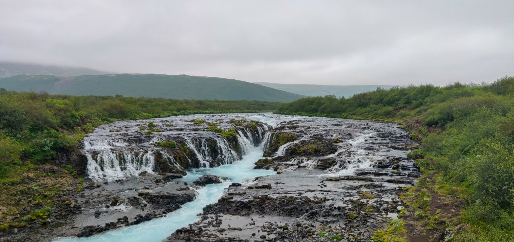
If you cross the bridge, you’ll see a small path on your left that seems to lead down to the banks of the river but actually takes you to a small viewing point under the bridge, large enough only for a couple of people to sit. It’s a beautiful and more intimate spot for you to admire the waterfall and take it all in.
Geysir and Strokkur
The steamy siblings
A real tourist hotspot, and not only because of the 80 to 100°C water that spouts from the ground in a steamy column of water, Geysir and Strokkur will probably be your first taste of Icelandic geothermal activity (although the water from natural geothermal springs that supply Reykjavik might count).
Now before you get too excited, Geysir which is the largest geyser at the geothermal field, is mostly inactive these days. Indeed, as its geothermal activity has calmed down, the dormant giant has gone into retirement and provides instead a serene display of turquoise water and orange shades of soil.
Its younger brother Strokkur on the other hand is very active, spitting columns of water up to 30 meters in the air every few minutes.
Time for a crash course in geyser science! As the water flowing through the underground channels meets hot bedrock and heats up, it starts building pressure. When the water has reached peak temperature and pressure, it explodes out from the geyser in a mix of boiling steam and spray.

In the seconds leading up to the explosion, you’ll see the water in the crater flow in and out, almost as if it were breathing (or sneezing…but that’s less poetic, although probably more accurate) before forming a huge bubble for a split second and exploding into the air.
If you get your timing right, you might even be able to snap a picture of that perfect moment before the bubble pops.
If you want to stretch your legs a little after patiently waiting to get your ideal picture, there is a short hike you can go on that leads up the hill that overlooks the geyser field. From this higher vantage point, you’ll get to see the full geothermal area in all its glory and admire Strokkur’s display in a less crowded atmosphere.
Þingvellir National Park
A historical place
Þingvellir is situated in a rift valley that marks the crest of the Mid-Atlantic Ridge and the boundary between the North American and Eurasian tectonic plates, and spans across 240km2. The national park was designated a UNESCO World Heritage Site in 2004 for its historic significance and diverse flora.
The name Þingvellir (pronounced thingvellir) is derived from the old Norse Þingvǫllr, which is a combination of the words Þing (pronounced thing) that means “assembly”, and vǫllr which means “field”, giving us the “assembly fields”. Indeed, it was the site of the Alþing, the annual parliament of Iceland from the year 930 until the last session held in 1798.

There are a few things to do around Þingvellir including diving between two tectonic plates in the Silfra rift, taking a walk through the park up to the Öxarárfoss waterfall, or visiting the cultural center for an Icelandic history lesson. It’s also a popular area for hiking and horseback riding.
The park is breathtaking, and like much of Iceland’s landscapes, it forces you to review your sense of scale. The towering rock being pushed out of the ground by the power of the continental plates reminded me of The Wall in Game of Thrones minus the White Walkers (although you’ll see the odd pale tourist), stretching out as far as the eye can see. The whole valley seems to be tearing apart, as the continental plates that meet there move further apart every year (on average 2,5cm per year).

Whether you’re a history buff, a geology lover, or just a fan of marvelous landscapes, this is a must see on your trip.
To park at one of the five parkings availabl, you’ll have to pay a small fee depending on the kind of vehicle you’re driving. You can find out more information and a detailed map of the parking, walks and attractions on the Þingvellir National Park website.
Gullfoss
The Golden Falls
On a sunny day, the waterfall is often ornate with a rainbow going from one bank to the other, lending a mystical touch to the place. Almost like the Bifröst, the bridge that connects Mitgard (Earth) to Asgard (the land of the gods) in Norse mythology.
The torrent of water seems to empty itself into the very bowels of the earth, digging the canyon that stretches out before it. Gullfoss really is one of the most beautiful waterfalls we saw on throughout our entire trip.

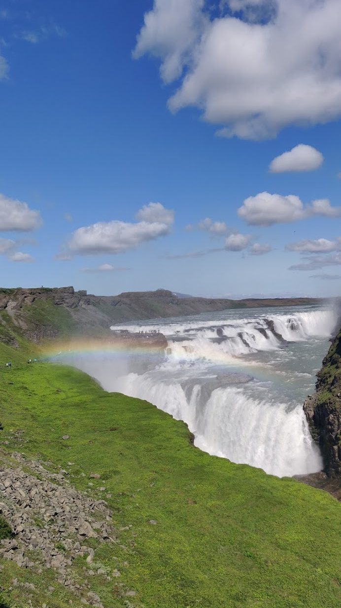
There are a few viewpoints from which you can see the waterfall, and most people tend to flock towards the one closest to the falls. Although it’s definitely worth going to see the golden falls up close to be showered in the spray and experience the deafening sound of the crashing water, the best view for us was the furthest viewpoint directly opposite the waterfall, which you can access from the parking through a staircase.
The parking is quite large, so you won’t have any trouble finding a spot, and rest assured there’s no fee this time. The only tribute you’ll have to pay is to take in the natural splendor this unique place has to offer.
Kerid
The Eye of the World
Our first stop on the Golden Circle was at Kerid Crater, which allowed us to get our legs warmed up for the day ahead. You can take a walk around the rim of the red crater and the small lake that lies in its center quite quickly, and there’s even a footpath near the starting point from where you can go down into the crater itself and the lake.
There’s a small fee of 400 ISK to visit the area which goes towards preserving it and the surroundings. You can pay by card at the small cabin near the parking, and children under 12 get to visit for free.
The walk itself and going down to the lake will probably take you around 30 minutes, but you mind end up staying longer, hypnotize by the blue eye that lies at the center of the crater’s red slopes.
Faxi and Urriðafoss
By now you might have guessed that “foss” is the Icelandic word for waterfall. Had you figured it out?
Throughout this blog series, you’ll see that we visited many waterfalls across the island (almost 40 if I’m not mistaken…). To be honest with you though, when it comes to Faxi and Urriðafoss, we didn’t see what all the foss was about (sorry for the pun…).
Let’s start with Faxi, where you’ll have to pay a 750 ISK fee to access the parking (I’m not sure if this is also an entrance fee for visiting the waterfall). The pathway leading to it is short and comfortable, and there is a café overlooking the waterfall if you fancy a warm drink. The waterfall itself is nothing spectacular, although it can be refreshing on a hot day as you can really get close to the water and enjoy the colling spray it provides.
As you can see from the itinerary I shared earlier, going to Urriðafoss will take you on a bit of a detour further south. Not a long detour mind you, but that’s half an hour you could probably spend better at another spot. The waterfall itself is quite nice, and it’s a popular spot for local fisherman. Beyond that, I would only recommend making the stop if you have some time on your hands or on your way around the ring road.
The “not so” Secret Lagoon
The Secret Lagoon is a popular stop on the Golden Circle tour, one that we chose to pass on in favor of other hot pool experiences. The geothermal pool located on route 30 near Reykjavik is meant to be the oldest in Iceland, dating back to 1891. An entrance of 3000 ISK per person (free for children and 2200 ISK for seniors) will give you access to the facilities including showers and a bistro for drinks and snacks. You can find all the details, including opening seasonal opening hours on their website.
If you do decide to stop for a dip in the lagoon, I suggest you do so at the end of the day, travelling clockwise along the Golden Circle by starting with Thingvellir, to enjoy a relaxing soak in the warm pool after a long day exploring.
Remember though, the lagoon is manmade, but if you want to discover truly wild geothermal pools, there are plenty of alternatives if you know where to look. One of which, and this was a highlight of the trip for us, was the Reykjadalur Hot Spring Thermal River, but that is a story for another time.
Our thoughts
As you can probably tell, our highlights of the Golden Circle were the two main waterfalls, Brúarfoss and Gullfoss, the geysers, and Þingvellir. All of which are situated along the stretch of road from route 35 to 37, making your Golden Circle more of a Silver Trail perhaps?
If you really want to make the most of these places and not end up rushing through them, you’ll need the full day. The walk to Brúarfoss and visiting Þingvellir alone will take you a good five hours (not counting driving between them), and you’ll probably spend more time than you realize mesmerized by the show Strokkur will put on for you.
We also found ourselves making quite regular stops to take in the scenery as we drove through Thingvellir National Park, as there are some beautiful viewpoints scattered along the way.
Kerid is certainly worth seeing if you have the time, after all you are in the land of ice and FIRE. It’d be a shame to not see at least one volcano, albeit an extinct one. However, if you’re headed to the Snæfellsnes Peninsula on your trip, as did we, you’ll be treated to much more spectacular volcanic views and get to see where Iceland gets its fiery reputation.
So, what’s on your Golden Circle tour? If you’ve already been, did you discover some unique stops along the way?
I’d love to hear from your experience, so please feel free to share what made your journey special in the comments below.
Until next time roamers!
